Getting modern runkeeper gpx into old
National Geographic Topo!
Overview
This page was written in October of 2018. I was (and still am)
a big fan of National Geographic Topo! software. Unfortunately years
ago National Geographic discontinued this product. I still consider
it a better representation of hikes than say Google Earth or the
topo overlay of Google Maps. The version of Topo! that I have is
4.2.6 from 2006. Does anyone have a newer version. Despite having a
good visualization of hikes, getting data into the maps leaves
something to be desired. This web page will go over how to do
it as much as for me as for anyone else reading this page :-)
Runkeeper
For some time now I have been using smart phones for my gps unit. A
number of years ago I took my Samsung S3 on a hike with phone and
wireless off, and my Garmin. GPS is independent of the cell towers
so you do not need phone signal or wireless to record tracks. The
Samsung never lost track while the Garmin did. I am now at an Iphone
8. In both cases I use Runkeeper for my tracks. When the hike is
done, the data is uploaded to runkeeper and you can then download a
gpx file from their web site. This gpx file will load into
Google Earth just fine. For the rest of this web page I will
use a hike Marina and I did with the pups on Oct 19, 2018 in our
"backyard".
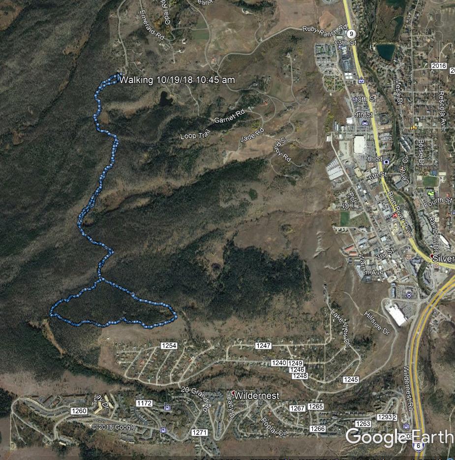
In Google Earth, the hike looks like this from the gpx file:
Here is the same gpx file imported into google maps with the
"terrain" overlay:
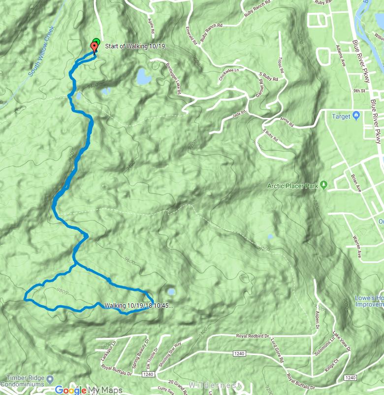
The problem with the google maps contours is that the contours are
faint and hard to read, and if you zoom in, they disappear
altogether. Zooming in to the 9800 foot contour just to the left of
the "Walking 10/19/118 10:45..." near the bottom left of the map:
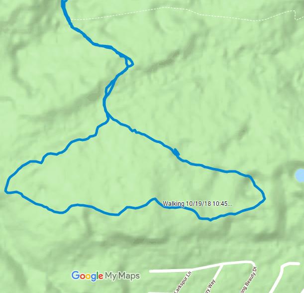
For some reason the contours disappear completely. Not really
acceptable.
Here is what the same gpx file looks like from Topo!:
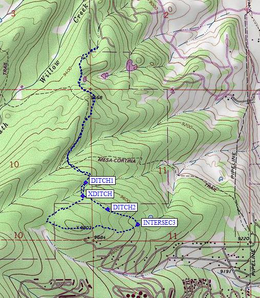
and if I printed it out in black and white to carry with me on a
hike:
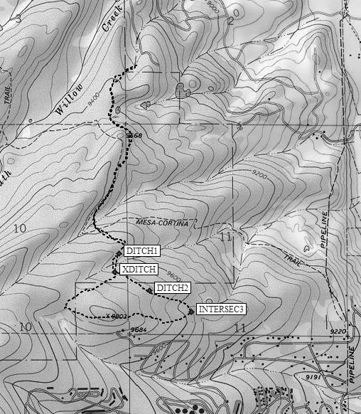
In both cases I consider the Topo! much more readable than Google.
However, to get to this point requires a significant amount of work,
which includes working around flaws in the Topo! program when it
comes to "routes".
Getting Runkeeper GPX into Topo!
I first tried to just import the gpx file and this came up:
This is done by
Handhelds > Import from GPS or Txt Wizard:
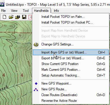
This brings up this window:
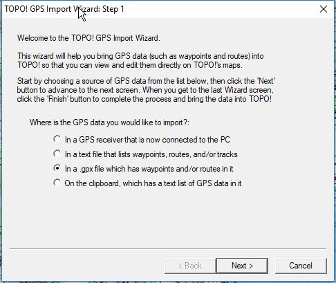
After selecting the gpx file from Runkeeper to import, Topo! gives
this error message:
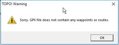
After taking some of my old Topo! files and exporting them to the
GPX format, I figured out how to edit the Runkeeper GPX to be
compatable.
Editing GPX
Here are the first few lines as Runkeeper generated:
<?xml version="1.0"
encoding="UTF-8"?>
<gpx
version="1.1"
creator="Runkeeper - http://www.runkeeper.com"
xmlns:xsi="http://www.w3.org/2001/XMLSchema-instance"
xmlns="http://www.topografix.com/GPX/1/1"
xsi:schemaLocation="http://www.topografix.com/GPX/1/1
http://www.topografix.com/GPX/1/1/gpx.xsd"
xmlns:gpxtpx="http://www.garmin.com/xmlschemas/TrackPointExtension/v1">
<trk>
<name><![CDATA[Walking 10/19/18 10:45
am]]></name>
<time>2018-10-19T16:45:54Z</time>
<trkseg>
<trkpt lat="39.642540000"
lon="-106.100764000"><ele>2847.5</ele><time>2018-10-19T16:45:54Z</time></trkpt>
<trkpt lat="39.642483000"
lon="-106.100956000"><ele>2848.3</ele><time>2018-10-19T16:46:11Z</time></trkpt>
<trkpt lat="39.642468000"
lon="-106.101074000"><ele>2849.0</ele><time>2018-10-19T16:46:27Z</time></trkpt>
<trkpt lat="39.642430000"
lon="-106.101193000"><ele>2849.8</ele><time>2018-10-19T16:46:46Z</time></trkpt>
<trkpt lat="39.642384000"
lon="-106.101304000"><ele>2850.5</ele><time>2018-10-19T16:46:58Z</time></trkpt>
<trkpt lat="39.642333000"
lon="-106.101416000"><ele>2851.3</ele><time>2018-10-19T16:47:09Z</time></trkpt>
<trkpt lat="39.642315000"
lon="-106.101533000"><ele>2852.7</ele><time>2018-10-19T16:47:19Z</time></trkpt>
<trkpt lat="39.642261000"
lon="-106.101637000"><ele>2854.2</ele><time>2018-10-19T16:47:29Z</time></trkpt>
<trkpt lat="39.642207000"
lon="-106.101733000"><ele>2855.6</ele><time>2018-10-19T16:47:37Z</time></trkpt>
<trkpt lat="39.642144000"
lon="-106.101823000"><ele>2857.0</ele><time>2018-10-19T16:47:49Z</time></trkpt>
<trkpt lat="39.642075000"
lon="-106.101898000"><ele>2858.3</ele><time>2018-10-19T16:48:07Z</time></trkpt>
The problem is that Topo! is looking for xml tags that are either
waypoints or routes, not tracks This is from a Topo! export:
Waypoints first
<?xml version="1.0"
encoding="UTF-8"?>
<gpx xmlns="http://www.topografix.com/GPX/1/1" version="1.1"
creator="National Geographic Maps TOPO! 4.1"
xmlns:xsi="http://www.w3.org/2001/XMLSchema-instance"
xsi:schemaLocation="http://www.topografix.com/GPX/1/1
http://www.topografix.com/GPX/1/1/gpx.xsd">
<metadata>
<bounds
minlat="39.6370792388916" minlon="-106.1180678606033"
maxlat="39.6556618213654" maxlon="-106.1017858982086"/>
</metadata>
<wpt lat="39.6556618213654"
lon="-106.1161890029907">
<ele>2919.690</ele>
<time>2018-10-20T14:35:05Z</time>
<name>X010</name>
</wpt>
<wpt lat="39.6545072793961"
lon="-106.1154711246491">
<ele>2938.890</ele>
<time>2018-10-20T14:35:06Z</time>
<name>X011</name>
</wpt>
and the route second:
<rte>
<number>1</number>
<rtept
lat="39.6556618213654" lon="-106.1161890029907">
<ele>2919.690</ele>
<time>2018-10-20T14:35:05Z</time>
<name>X010</name>
</rtept>
<rtept
lat="39.6545072793961" lon="-106.1154711246491">
<ele>2938.890</ele>
<time>2018-10-20T14:35:06Z</time>
<name>X011</name>
</rtept>
<rtept
lat="39.6533813476563" lon="-106.1149193048477">
<ele>2950.470</ele>
<time>2018-10-20T14:35:06Z</time>
<name>X012</name>
</rtept>
So I edited the Runkeeper GPX file to change tracks to routes:
<?xml version="1.0"
encoding="UTF-8"?>
<gpx
version="1.1"
creator="Runkeeper - http://www.runkeeper.com"
xmlns:xsi="http://www.w3.org/2001/XMLSchema-instance"
xmlns="http://www.topografix.com/GPX/1/1"
xsi:schemaLocation="http://www.topografix.com/GPX/1/1
http://www.topografix.com/GPX/1/1/gpx.xsd"
xmlns:gpxtpx="http://www.garmin.com/xmlschemas/TrackPointExtension/v1">
<rte>
<name>PLACER</name>
<time>2018-10-19T16:45:54Z</time>
<number>1</number>
<rtept lat="39.642540000"
lon="-106.100764000"><ele>2847.5</ele><time>2018-10-19T16:45:54Z</time></rtept>
<rtept lat="39.642483000"
lon="-106.100956000"><ele>2848.3</ele><time>2018-10-19T16:46:11Z</time></rtept>
<rtept lat="39.642468000"
lon="-106.101074000"><ele>2849.0</ele><time>2018-10-19T16:46:27Z</time></rtept>
<rtept lat="39.642430000"
lon="-106.101193000"><ele>2849.8</ele><time>2018-10-19T16:46:46Z</time></rtept>
<rtept lat="39.642384000"
lon="-106.101304000"><ele>2850.5</ele><time>2018-10-19T16:46:58Z</time></rtept>
<rtept lat="39.642333000"
lon="-106.101416000"><ele>2851.3</ele><time>2018-10-19T16:47:09Z</time></rtept>
<rtept lat="39.642315000"
lon="-106.101533000"><ele>2852.7</ele><time>2018-10-19T16:47:19Z</time></rtept>
<rtept lat="39.642261000"
lon="-106.101637000"><ele>2854.2</ele><time>2018-10-19T16:47:29Z</time></rtept>
<rtept lat="39.642207000"
lon="-106.101733000"><ele>2855.6</ele><time>2018-10-19T16:47:37Z</time></rtept>
<rtept lat="39.642144000"
lon="-106.101823000"><ele>2857.0</ele><time>2018-10-19T16:47:49Z</time></rtept>
<rtept lat="39.642075000"
lon="-106.101898000"><ele>2858.3</ele><time>2018-10-19T16:48:07Z</time></rtept>
<rtept lat="39.642055000"
lon="-106.102015000"><ele>2859.5</ele><time>2018-10-19T16:48:22Z</time></rtept>
<rtept lat="39.642010000"
lon="-106.102121000"><ele>2860.6</ele><time>2018-10-19T16:48:37Z</time></rtept>
<rtept lat="39.641972000"
lon="-106.102232000"><ele>2861.8</ele><time>2018-10-19T16:48:49Z</time></rtept>
<rtept lat="39.641937000"
lon="-106.102342000"><ele>2862.8</ele><time>2018-10-19T16:49:03Z</time></rtept>
At this point, Topo! can read the file:
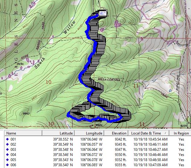
It took each reading and assigned it a way point. In the view above
I have Topo! showing just the names of the waypoints. Turning the
names off, I get:
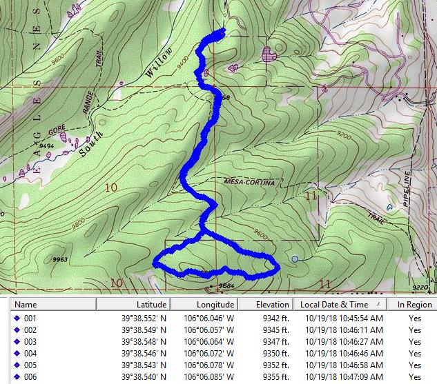
This is more readable but if you want to highlight with waypoints
only a few features as in the picture at the top of the page, it can
not be done.
Zooming in at 400% mag, you can see lines connecting each waypoint:
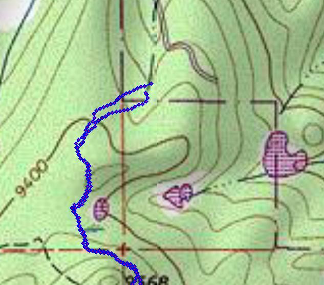
But I can not see a route per se that Topo! can use.
Even if you delete some waypoints so that the connecting line
becomes longer like this:

the route itself does not appear to be clickable to build a profile.
If you hide all the waypoints the map becomes completely empty.
So what I have found I have to do is to use the route tool to hand
draw with the mouse a new route on top of the GPX route like this:
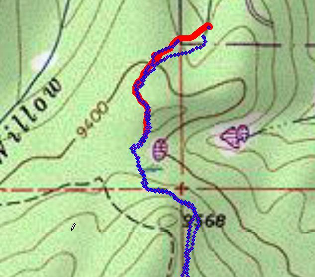
This is a bit tedious, but once done, you can delete all of the GPX
waypoints then go back and add your own. In addition, you can get a
profile and distance, and the export as a printed map looks like
this:
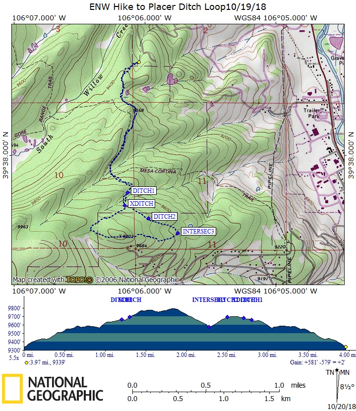
The magnetic declination is somewhat out of date, according to the
web it is more or less 8 degrees 41 minutes vs the map of 8 degrees
30 minutes.
If anyone with a better knowledge of Topo! than me reads this page
and has suggestions, please send me an email (shown at the bottom of
the page). If anyone has a later version of Topo! than the Ver 4.2.6
and would be willing to sell me the disks, also contact me below.
Back to Snowedunder's home page.
Feedback to:

This page last updated on October 20, 2018 by Don Samuels